
Pavement Management - Metro Nashville (Davidson County), TN

Collier staff implemented, maintains, and operates Metro’s Cartegraph, ArcGIS, and ArcSDE Geo-Database. We have implemented systematic approaches for identifying newly accepted roads and centerline segments that have been split, combined, or removed. This process is essential for the integrity of the centerline database that Metro provides to ARA, a third party annual roadway condition data collection firm. Collier staff also extracts and compiles data from the asset management system Cartegraph to prepare reports, charts, and graphs for presentation and inclusion in various annual departmental and Metro financial reports.
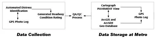
Metro Nashville Paving Division (Metro) uses an advanced automated data collection process to capture pavement distress data along with a GPS Photo log that captures images every 20 feet. Metro’s Pavement Management staff rely heavily on computer systems and have implemented Cartegraph to house distress data and roadway images for further analysis and tracking purposes. Metro also uses ESRI ArcGIS software suite and custom extensions along with Cartegraph to generate a condition rating for each roadway segment. Metro reviews the final deliverables and makes necessary updates to the GIS system to create paving project lists.
Client:
Metro Nashville Public Works Department