
USD Expansion Streetlight / Utility Pole Collection
Metro Nashville (Davidson County), TN

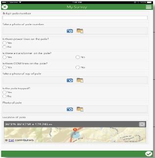
The Urban Services District Expansion Streetlight/Utility Pole Collection project was completed in September of 2017 for Metro Nashville Public Works. This job involved collecting data for all utility poles and streetlights in the USD expansion. This data includes location, pole attributes, streetlight attributes, and images of the poles.
The data was collected in the field using ESRI’s latest mobile data collection tools and analyzed using ESRI ArcGIS Desktop and ArcGIS Online software. Our data collection team covered more than 120 miles of streets over a month to document each utility and streetlight pole. In the office, our GIS analysts reviewed each pole and made suggestions regarding new light and pole placement to help MNPW ensure that the USD expansion area meets all street lighting requirements.
The resulting data was compiled into a report containing a written description of the project, a table, and several maps of the data. The information was displayed in several different forms to ensure that the client could easily understand it. A large 30” x 42” map of the data collected was also delivered to the client. Additionally, a file geodatabase containing all of the data and attributes collected was created and given to MNPW.
Client: Metro Nashville Public Works Department